
Regional Water Planning
Ensuring Texans have adequate supplies to meet the future water needs and the ability to withstand future droughts requires a great deal of planning and implementation. Water planning is a high priority of Nueces River Authority (NRA).
NRA works with several Regional Water Planning Groups to ensure adequate and affordable water supplies are available for Texans. Working in partnership with the Texas Water Development Board (TWDB) the state’s lead water planning and infrastructure financing agency, NRA has staff dedicated to the preparation of the State of Texas Water Plan which reflects and responds to changes in population, water supplies, technological improvements, economic shifts, state policy and viability of planned projects. The water plan for Texas is updated every 5 years pursuant to Senate Bill 1, enacted by the 75th Texas Legislature.
The state is divided into 16 regions, each includes a Regional Water Planning Group, which consider data provided by the TWDB with respect to present population and water demands. This information is evaluated along with the adequacy of current water supplies to identify water surpluses or supply needs within the region. Water management strategies (projects) identified to meet water needs under 3 dry weather (drought conditions) scenarios. Recommendations are made within the regional plan and those plans are combined and included in the Texas Water Plan.
NRA is the group sponsor for the Coastal Bend (Region “N”) Regional Water Planning Group. In this capacity, NRA is responsible for the development of the water plan for the Coastal Bend Region. NRA works with the planning committee to select a technical consultant, assure all meetings of the group are compliant with the Texas Open Meetings Act, and the plan is developed on time and within funding allocations.
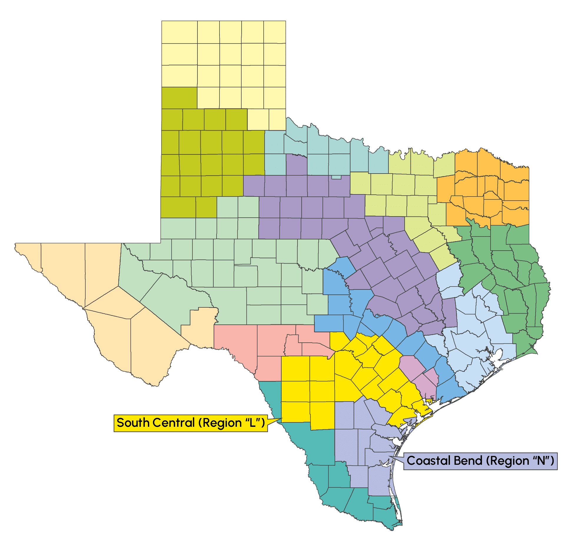
2 NRA staff members serve as voting members of the South-Central Texas Regional (Region “L”) Water Planning Group. NRA also has staff that serve as Liaisons between groups with contagious boundaries.
For more information with respect to NRA’s water planning, please contact Travis Pruski, Chief Operating Officer, Nueces River Authority at tpruski@nueces-ra.org.
Nueces Basin Regional Flood Planning
In 2019, the 86th Legislature passed legislation to develop the first flood plan for the State of Texas. The legislation also established a Flood Infrastructure Fund of approximately $3.3 billion from the state’s economic stabilization fund and an Infrastructure Resiliency Fund that allows cities, counties, and other political subdivisions of the state to apply for grants and low – or zero interest loans for specific projects. The flood planning as well as the funding are administered by the Texas Water Development Board (TWDB).
The Nueces River Authority (NRA) is one of 15 organizations selected to assist with the development of the State Flood Plan. As sponsor of the Nueces Flood Planning Group , NRA is responsible for drafting a regional plan to be included in the overall flood plan for the state. To develop the plan, NRA contracts with a technical consultant, assures each meeting of the flood planning group is advertised and conducted in accordance with the open meetings act, monitors expenditures to ensure the regional plan is developed within allocated funds, and provides a conduit for communication between the public, the planning group, the technical consultant, and the TWDB.
The Nueces Flood Planning Group, also referred to as Region 13 Flood Planning Group represents the following counties:
Aransas*
Atascosa*
Bandera*
Bee
Bexar*
Brooks*
Calhoun
Dimmit*
Duval
Edwards*
Frio
Goliad*
Jim Hogg*
Jim Wells
Karnes*
Kenedy*
Kerr*
Kinney*
Kleberg
La Salle
Live Oak
Maverick
McMullen
Medina*
Nueces
Real*
Refugio*
San Patricio
Uvalde
Webb*
Wilson*
Zavala
*Indicates this county is partially within this Regional Flood Planning Group (RFPG) and is also represented by at least one other RFPG.
The Nueces Regional Flood Planning Group has a population of approximately 782,500 people and contains approximately 24,094 square miles. From 1975 to 2019 this area had approximately $270,467,100 in National Flood Insurance Program claims.
The area has 2 cities with population greater than 25,000, Corpus Christi and Kingsville and includes the Barney M Davis, Choke Canyon, and Lake Corpus Christi Reservoirs. Streams within the area are the Sabinal, Atascosa, Leona, Frio, and Nueces Rivers. The Nueces and Baffin Bays are also included.
Philip Wiatrek, Director of Planning
Bio coming soon
